Where Vision Meets
Geospatial Excellence
Supporting Global Infrastructure and Engineering Projects with Reliable Spatial Data Scalable Production Workflows Skilled Geospatial Experts Smart Infrastructure Solutions Trusted Client Partnerships
Inside Unique Maps
UniqueMaps was born in 2012 and has now grown into a leading Geospatial Industry with a good number of employees across India. We work on the latest technologies and advanced applications to fulfill the requirements of our clients. Delivers accurate and reliable solutions for all types of GIS and AEC-related projects
We constantly work towards continuous improvement of technology, employee productivity, and processes. Our only goal is to continue setting industry-leading standards in providing customers with cost-effective GIS solutions that meet project quality, technical and schedule requirements, within available budgets.
Our core strength lies in quality assurance and timely delivery, enabling us to build long-term relationships with our clients. We add value to our customers’ processes and products by significantly reducing product lifecycle time and cost.
With a well-trained workforce and experienced GIS experts, we have the capability to handle large and critical projects. Our team combines deep domain knowledge with innovative solutions to deliver exceptional results.
Next level of Mapping & BIM services
We are proud to have more than 100 satisfied customers across the globe.
Our Achievements
Est.
2012
Over a Decade of Excellence
For over a decade, Unique Maps has been delivering reliable GIS, LiDAR, geospatial, and BIM solutions with a strong focus on quality and accuracy.
0
+
Completed projects
Successfully delivering high-quality geospatial, GIS, LiDAR, and BIM projects across multiple industries with accuracy and reliability.
0
%
Satisfied customers
Trusted by clients across multiple industries for delivering reliable and high-quality geospatial solutions. We focus on accuracy, timely delivery, and long-term customer satisfaction.
Why We’re Preferred
Our Prime Goals: Customer Satisfaction Quality Delivery Timely Delivery
Trusted partner
We think of ourselves as your trusted partner. You can put your trust in the quality of our data, our expertise,and our problem-solving capabilities.
Quality & cost-effective
Our clients tell us time and again that the quality of our services is what makes us stand out from the crowd,You can trust the accuracy and the quality of the service that we deliver .We price all of our services competitively, providing cost-effective solutions.
Technology & Innovation
We make sure that we keep up-to-date with the latest technology,we are always pushing to be at the forefront of the leading technologies, the most current industry developments and the latest products and services.
Speed of service
We know that, for your business, time is often of the essence. That’s why we provide a quick and responsive turnaround service on all that we offer.
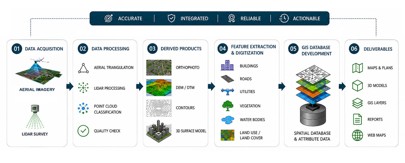
Integrated Geospatial Solutions
We provide integrated geospatial solution packages by combining multiple services into a single efficient workflow. Our solutions help clients get accurate terrain, infrastructure, and spatial data for city planning, land development, utility mapping, transportation corridors, and large infrastructure projects.
We support projects with aerial image processing, high-resolution orthophoto generation, LiDAR terrain modeling, digital elevation model and digital terrain model creation, topographic mapping, utility feature extraction, digitization, and GIS database development. These services help improve planning, engineering, design, and decision-making processes.
By combining advanced geospatial technologies into a single workflow, we help reduce project complexity, improve data accuracy and consistency, accelerate project delivery, and support modern engineering and development projects with reliable spatial information.